
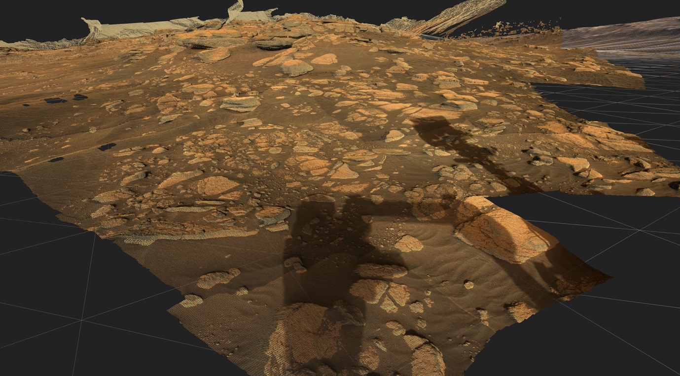
Highly detailed 3D reconstructions from satellite and rover instrument data enable geologists to analyze the geological properties of distant celestial objects such as Mars. Geological interpretations are an important part of this, providing answers to questions such as the history of planets, the probability of earlier water deposits or possible locations for bio-signatures. For this purpose, we provide interactive tools that allow comprehensive exploration as well as various measurements and annotations on high-resolution 3D models down to the smallest detail.
Developed to support NASA and ESA missions, PRo3D allows easy navigation through high-resolution 3D reconstructions of planetary surfaces with the ability to carry out extensive geologic interpretations.
PRo3D, short for Planetary Robotics 3D Viewer, is an interactive 3D visualization tool that allows planetary researchers to work with high-resolution 3D reconstructions of the surface of Mars.
PRo3D supports planetary researchers of NASA and ESA in their quest to find signs of life on the red planet by examining high-resolution 3D surface reconstructions from orbiter and rover cameras. During our successful collaboration with the Imperial College of London, PRo3D has proved to be the researchers' main tool for conducting remote geological analyses, leading to many publications and lectures in various places of geological science.

For the construction of tunnels, it is essential to analyze exactly what the rock in which you are going to drill is made of and what its special properties are. This is a question of safety as well as of estimating costs and time. Digital systems that allow the annotation of high-precision 3D reconstructions of the working face are the ideal complement to on-site analysis.
The Geotunnel Viewer, developed in collaboration with our industrial partner Geodata, integrates information from sensor data with 3D scenes. The viewer creates a combined, user-friendly presentation of the respective geological conditions and also allows efficient comparisons. As special features, the interactive monitoring tool offers data-driven navigation to critical measurements, a virtual reality mode and embedded storytelling.

Minerals from the spinel group provide useful information about the geological environment in which the rocks were formed and therefore play an important role in the search for economically interesting mineral deposits. In cooperation with partners from Argentina, we were able to significantly improve the analysis and classification process of spinels: our solution requires only a few minutes to analyze minerals. It combines well-known principles of interactive visual analysis (e.g. coordinated multiple views) and diagrams that are usually used for analyzing minerals of the spinel group. A web-based solution has been developed by our partners in Argentina.
Our research work with spinel group minerals and the technologies we use for holistic interactive visual analysis has already been presented at prestigious conferences and as scientific papers. Most recent:Antonini, A. S., Ganuza, M. L., Ferracutti, G., Gargiulo, M. F., Matković, K., Gröller, E., ... & Castro, S. M. (2021). Spinel web: an interactive web application for visualizing the chemical composition of spinel group minerals. Earth Science Informatics, 14(1), 521-528.; read here

Automatic creation of visualization models in VR through interface from GIS to XR enables faster mission planning.
PanCam-3D focuses on the further development of interactive 3D visualizations for the ExoMars 2022 mission.
Visual Analysis of Asteroid Deflection.
WIBSTAC addresses the usage of wide baseline stereo 3D reconstruction for medium- and long-range mapping of the Martian surface, based on imagery from panoramic rover camera instruments.
Support for planetary research: Visual analysis of reconstructions of the Mars surface and view planning for rover camera instruments.
The "Mars-DL" project is investigating how a deep learning system can support the research work of planetary scientists through object and pattern recognition. For this project VRVis has extended the functionality of PRo3D to automatically render shatter cone training images.
Virtual exploration and geological analysis of reconstructed Mars surfaces and rock outcrops.
MINERVA is an integrated framework for planetary scientists allowing members of different instrument teams to cooperate synergistically in virtual workspaces by sharing observations, analyses and annotations of heterogonous mission data.
A visual tool for a combined stratigraphic and temporal documentation and interpretation of excavation projects.
Strategic Research in Scalable, Semantic Rendering.
Planetary Robotics Vision Data Exploitation.
Seamless visual analysis of data involving 3D geometry, relational information and multivariate attributes.